Header image: USFWS – CC BY 2.0
The grasslands of the Charles M. Russell National Wildlife Refuge are the remnants of a prairie habitat that used to cover a quarter of the United States – an area that has remained mostly undisturbed since the Lewis and Clark expedition passed through here in 1805. It also contains the largest hydraulic dam in the United States – Fort Peck Dam.
This is a place where several Tyrannosaurus Rex fossils have been discovered, and it continues to offer up treasures to scientists, providing glimpses into prehistoric times and the animals that once roamed this land.
The area also serves as a place of rest, recreation, and enjoyment for locals. People come here to boat, swim, hike, camp, and take scenic drives through a remote and stunning landscape year-round.
Here’s everything you need to know for your next visit to the Charles M. Russel National Wildlife Refuge – from opening hours and lodging options, to whether or not you can fly drones inside the refuge!
In this article:
- Quick facts and stats – Charles M. Russell National Wildlife Refuge
- Where the Refuge is located (Map)
- How to get there
- Opening hours
- How big it is (acres)
- These are the animals that live in the Refuge today
- The best time to visit
- Things to do in the refuge
- Camping in the Charles M. Russell National Wildlife Refuge
- Visiting the refuge with RVs or cars + trailers
- Are pets allowed in the refuge?
- Lodging in the Charles M. Russell National Wildlife Refuge
- Hunting the Charles M. Russell National Wildlife Refuge
- Flying drones in the Charles M. Russell National Wildlife Refuge
- Why did they name this Montana refuge after Charles M. Russell?
Quick facts – Charles M. Russell National Wildlife Refuge
- Size: 1.1 million acres (445,154 hectares)
- Length: 125 miles (201 km)
- Date established: 1936
- Terrain: Sweeping grasslands, rocky buttes, badland features, canyons, reservoir
- Ecological regions: Rivers, wetlands, shoreline, and uplands
- Road quality: Around the dam: good. Elsewhere: unpredictable
- Wildlife: Elk, mule deer, white-tailed deer, pronghorn antelope, red fox, coyotes, bighorn sheep, cougars, prairie dogs, black-footed ferret, porcupines, beavers
- Raptors and birds: Eagles, hawks, quail, sharp-tailed grouse
- Endangered species: Grizzly bear, northern leopard frog, burrowing owl
- Nearby recreation areas: Upper Missouri River Breaks National Monument and the Woodhawk Wilderness Study Area
- Nearby towns: Glasgow, Wolf Point, Glendive, Miles City, Jordan, Lewistown, Malta
- Nearest major city: Billings (264 mi, 425 km, 4.5 hrs by car)
- Things to do: Biking, wildlife viewing, hiking, swimming, boating, camping, driving
- Interesting fact: Except for two roads that pass through the refuge (U.S. Route 2 and MT Highway 24) the land within the Refuge has remained undisturbed since the Lewis and Clark expedition passed through here in 1805.
Where is the Montana Charles M. Russell National Wildlife Refuge Located?
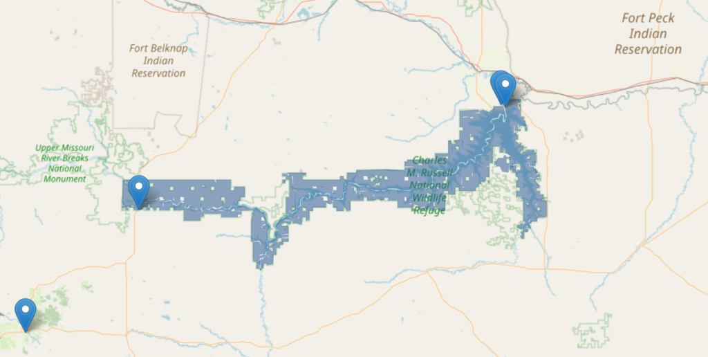
The Charles M. Russell National Wildlife Refuge is located near Glasgow, Montana, in north-central Montana. The headquarters for the Refuge is located in Lewistown, Montana, about a two-hour drive southwest of the Refuge.
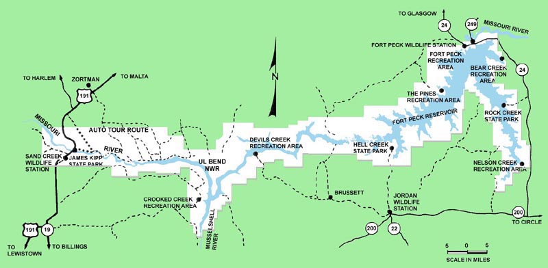
Two staffed field stations are located on either end of the park – the Sand Creek Field Station is on the west side and the Fort Peck Field Station is located on the east side, nearby the Fort Peck Interpretive Center.
Charles M. Russell National Wildlife Refuge map:
Use this interactive map to zoom in and locate the Charles M. Russell National Wildlife Refuge on the map in Montana:
Charles M. Russell National Wildlife Refuge boundary around Fort Peck Reservoir:
Charles M. Russell National Wildlife Refuge road map:
How to get to the Charles M. Russell National Wildlife Refuge
From the south (ex. Billings)
The nearest major city to the Charles M. Russell National Wildlife Refuge (CMR Refuge) is Billings.
- Drive north to Winnett via US 87 and MT 244
- In Winnet, turn east onto MT 200 and continue 2 hrs (112 mi, 180 km) to Flowing Wells Rest Area
- Turn north onto MT Highway 24 and continue for 1 hour (60 mi, 97 km) to Fort Peck
From the east (ex. Williston, ND)
- Drive 2.5 hours (131 mi, 211 km) west on Highway 2
- Turn south onto MT 117 and continue for 15 minutes (11 mi, 18 km) to Fort Peck
From the east (ex. Belfield, ND)
- Drive 1.5 hours (80 mi, 129 km) west on I-94 to Glendive
- Exit at Glendive northwest onto 200S and continue 45 minutes (49 mi, 79 km) to Circle
- At Circle, turn west onto MT 200 and continue 30 minutes (31 mi, 50 km) to Flowing Wells Rest Area
- Turn north onto MT Highway 24 and continue for 1 hour (60 mi, 97 km) to Fort Peck
From the west (ex. Missoula, MT)
- Drive 2.5 hours (153 mi, 246 km) east on MT 200 to Vaughn (turns into Highway 89 for the last 9 miles/14 km).
- Turn east onto I-15 and continue 20 minutes (13 m, 21 km) to Great Falls.
- Turn north onto Highway 87 and continue 2 hours (114 mi, 183 km) to Havre.
- Turn east onto Highway 2 and continue 2.5 hours (158 mi, 254 km) to Glasgow.
- Turn south onto MT 42 (in 3 miles, MT 42 turns into MT 24) and continue 10 minutes (18 mi, 29 km) to Fort Peck
Nearby airports
The nearest commercial airport to the Charles M. Russell National Wildlife Preserve (CMR Wildlife Refuge) is Logan International Airport in Billings.
Read our article about another Montana wildlife refuge, the National Bison Range, here
Opening hours – Charles M. Russel National Wildlife Refuge
There is no gate that controls access to the Charles M. Russell National Wildlife Refuge – visitors can explore the area year-round.
However, activities here are limited by the season. Most people visit from June to August when they can enjoy camping, boating, swimming, and other outdoor activities.
In winter, the reservoir is mostly frozen over and the land is covered in a blanket of snow, creating an enchanting atmosphere.
Headquarters (Lewistown – outside the boundaries of the Refuge)
- Monday through Friday (except holidays): 7:30 am – 4:30 pm
Fort Peck Field Station (east end of the Refuge, in Fort Peck)
- Monday through Friday (except holidays): 7:30 am – 4:30 pm
Sand Creek Field Station (west end of the refuge, in Roy)
- Monday through Friday (except holidays): 7:30 am – 4:30 pm
Fort Peck Interpretive Center (Fort Peck):
- Friday to Monday: 9 am – 4 pm
How many acres is the Charles M. Russell National Wildlife Refuge?
The Charles M. Russell National Wildlife Refuge covers 1.1 million acres (445,154 hectares) of land and stretches 125 miles (201 km) east-west along the upper Missouri River in north-central Montana.
It is the second-largest national wildlife refuge in the lower 48 states.
When President Roosevelt first established the Charles M. Russell National Wildlife Refuge in 1936, it contained a fraction of its current land area. A series of public orders throughout the 20th century gradually expanded the Refuge to its current size.
What animals live in the Charles M. Russell National Wildlife Refuge?
The Charles M. Russell National Wildlife Refuge is a prime location for wildlife viewing. There are four major ecological regions within the Refuge; rivers, wetlands, shorelines, and uplands. Visitors will see most of the larger mammals in the shoreline and upland areas.
See one of the largest remaining prairie herds of elk
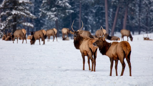
The Charles M. Russell National Wildlife Refuge (Charles M. Russell NWR) is home to a large prairie herd of elk. One of the Refuge’s most fascinating spectacles occurs in October when hundreds of elk gather in the fertile wetlands near the Slippery Ann Elk Viewing Area before winter sets in.
See one of the world’s last free-roaming black-footed ferret populations
Diseases and overhunting have led to a shrinking Black-footed ferret population. When the last of nine captive Black-footed ferrets died in 1978, scientists thought they were extinct.
However, in 1981, biologists found and gathered several of them from Wyoming and transported them to 18 isolated regions in the western states, such as the Charles M. Russell National Wildlife Refuge.
Biologists here are now nurturing the black-footed ferret populations back from near-extinction.
Raptors and birds
Eagles, hawks, sharp-tailed grouse, and quail.
Bugling elk, herds of mule deer, red fox, coyotes, and more
Pronghorn antelope, cougars, Rocky Mountain elk, pronghorn deer, white-tailed deer, mule deer, red fox, coyotes, beavers, and porcupines.
All of these animals call the Charles M. Russell National Wildlife Refuge (Russell Wildlife Area) their home.
See the Largest population of Rocky Mountain bighorn sheep outside of the Rocky Mountains
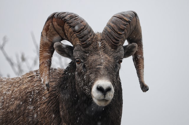
They stand strong and tall, with thick, enormous horns atop their robust head. One of the most spectacular creatures in Montana, and a conservation success story.
Overhunting, disease, and habitat loss have made it challenging for biologists to preserve them, but they managed to grow their population from fewer than 1,000 in the 1940s to roughly 5,000 by 2016.
Endangered species
The refuge is home to many endangered species, such as grizzly bears, northern leopard frogs, black-footed ferrets, burrowing owls, and many others.
Flora
Across much of this Montana wildlife refuge is low-growing grass and shrub. The wetlands include plants typical of wet, boggy regions and the open prairies feature small forests, grasslands, and buttes.
Discover the best national and state parks in Montana here
When is the best time to visit the Charles M. Russell National Wildlife Refuge?
The Charles M. Russell National Wildlife Refuge is open year-round. However, activities here are limited by the season. Most people visit during the warm summer months, from June to August.
During the summer, visitors come with camping equipment, picnicking amenities, bikes, or boats to explore the landscape and enjoy the waters of the Fort Peck Reservoir.
Some people prefer to visit during that special time of year, the winter months, when the Charles M. Russell National Wildlife Refuge is covered in a blanket of snow.
October elk congregation – NOT TO MISS
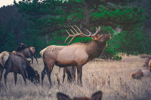
Each year, in late September and early October, peak numbers of elk gather around the Slippery Anne Elk Viewing Area. Records show that a group of up to 500 elk visits the viewing area in September.
Spring, summer, and autumn – Best times for wildlife sightings
The best time to see wildlife in the refuge is spring, summer, and autumn.
If you love seeing playful babies like fox kits and bear cubs, consider visiting this Montana wildlife refuge between early April and late June.
To catch the bugle of a bull elk or see herds of fully mature mule deer, it’s best to visit from late September to early October.
GRIZZLY BEAR ALERT!: The bear threat in Montana is real. Always carry bear bells and bear spray year-round when hiking, biking, or doing any outdoor activities in the state.
Do bear bells work? Find out here.
Things to do in the Charles M. Russell National Wildlife Refuge
There is a number of trails, historical and geological sites, and natural places to explore in the Charles M. Russell National Wildlife Refuge.
You can find multiple signs and information boards as you explore this Montana wildlife refuge. However, here are some of the major attractions and things to do within the Refuge.
1. Visit the Fort Peck Interpretive Center
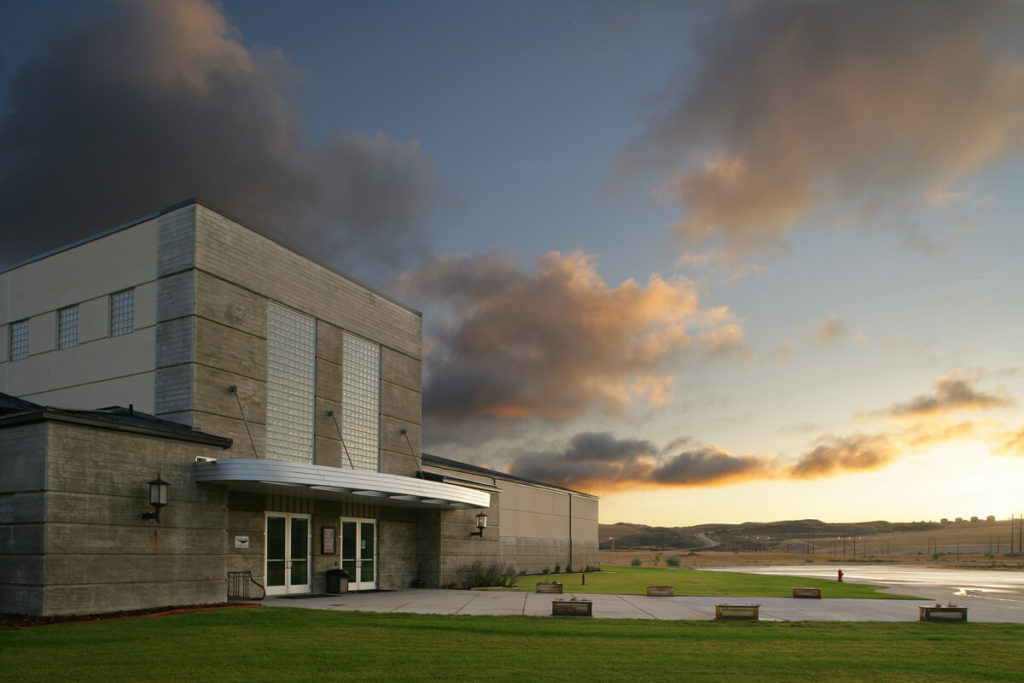
The Fort Peck Interpretive Center sits near the Fort Peck Dam. The Center is an educational center jointly managed by the U.S. Army Corps of Engineers and the U.S. Fish and Wildlife Service.
Visitors here can explore the history of the dam’s construction and see dinosaur fossils discovered within this Montana wildlife sanctuary. Here’s what to look forward to at the Fort Peck Interpretive Center:
Paleontology
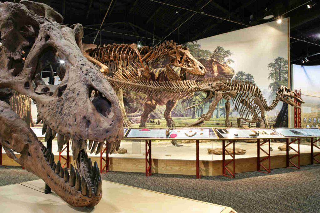
Greeting each visitor is the Fort Peck Lake signature dinosaur attraction – a life-size model of Peck’s Rex, a nearly complete Tyrannosaurus rex skeleton that Louis E. Tremblay found in 1997, 20 miles (32 km) from Fort Peck.
Other dinosaur fossils on display at the Interpretive Center:
- A full skeleton cast of the Struthiomimus – a long-legged, bipedal dinosaur resembling a large ostrich that could run 35 mph (56 km/h)
- Full mounts of prehistoric aquatic reptiles and fish hanging from the ceiling
This deep dive into the Mesozoic era is a must-see.
Wildlife
In addition to fossils, there is a wildlife exhibit featuring multiple animals from the past and present of the Charles M. Russell National Wildlife Refuge. This includes various animal displays and two aquariums showcasing native fish of the Fort Peck Reservoir and the Missouri River.
Fort Peck Dam Construction History and Archives
The Fort Peck Dam is the largest hydraulically filled dam in the world. Construction started in 1933 and was finished in 1940.
It is 21,026 ft (6,409 m) long, 250.5 ft (76 m) tall, and contains five turbines that can produce 185,250 kilowatts of power.
The name Fort Peck comes from the trading post and Native American agency that Commander E.H. Durfee and Colonel Campbell K. Peck established here in 1867. Fort Peck was a locale for the fur trade with the Sioux and Assiniboine tribes.
Visitors of the Fort Peck Interpretive Center can explore photographs, tools, and worker accounts of the dam’s construction. They can also learn about life in the boom towns that appeared around the dam during its construction but disappeared once construction was complete.
Opening hours of the Fort Peck Dam Interpretive Center
The Fort Peck Interpretive Center is open weekdays, 9 am – 4 pm, by appointment.
You can schedule an appointment 24 hours in advance here or by calling 406-526-3493.
2. Fort Peck Dam and Powerplant Museum
The Fort Peck Dam and Powerplant Museum is located in Power Plant #1, two miles (3.2 km) northeast of Fort Peck on Lower Yellowstone Road. There are exhibits on the history of Fort Peck Dam construction and fossils from the area on display.
3. Hiking
Several hiking trails* of varying difficulties wind throughout the Charles M. Russell National Wildlife Refuge.
Visitors can find comfortable, paved walking trails near the dam, by the Fort Peck Interpretive Center. The Milk River Overlook Trailhead is just northeast of the dam, across the Missouri River – a short, easily accessible trail to a lookout with a beautifully expansive view over the Missouri River. Here, Lewis and Clark decided not to take the Milk River on their expedition west.
*Hiking trails throughout the Charles M. Russell National Wildlife Refuge are sometimes few and far between and not well mapped. While driving through this Montana wildlife refuge, it’s common to cross long stretches of land without finding any trails to explore on foot.
Where are the best places to visit in Montana? Find out here
4. Biking
Those with a bike can truly enjoy exploring the Charles M. Russell National Wildlife Refuge (Montana Wildlife Center). Pick any of the paved or natural trails. Just beware that in remote regions, the trails can become few and far between.
Always be prepared by bringing ample food and drinking water with you and never lose your sense of orientation – always track the route back to your car, campsite, or the settlement you started from. Remember to bring bear spray, and enjoy.
5. Camping in the Charles M. Russell National Wildlife Refuge
There are numerous beautiful locations for camping in the Charles M. Russell National Wildlife Refuge. Many of the campsites are in remote locations, so remember to bring extra food, water, and fuel with you. Cell phone reception is also poor in most locations, so be sure you always come prepared.
Campgrounds in the Charles M. Russell National Wildlife Refuge
Below are some campgrounds in the Charles M. Russell National Wildlife Refuge:
Northeast (below the dam)
- Roundhouse Point Campground. Campground that sits between the Missouri River and the Dredge Cut Bay just a few miles from the Fort Peck Interpretive Center. One toilet. No RV hookups. No fee.
- Fort Peck Campground. Very close to the damn and the Fort Peck Interpretive Center, with some spacious, paid campsites and paved walking trails. No RV hookups.
Northeast (above the dam)
- Fort Peck Marina and RV Park. This campground sits just above the dam on the north shore of the reservoir. A clean and quiet RV park with a restaurant.
- West End Tent and Trailer Campground. A clean and comfortable campground just down the shoreline (west) from Fort Peck Marina and RV Park. Offers scattered trees, spacious pitches, and bathrooms. Paid.
Middle (north shore)
- The Pines Campground. On the north shore of the reservoir, about an hour’s drive (35 mi, 56 km) southwest of the dam. In a prairie setting with scattered trees and a hill offering a beautiful view over the reservoir. Picnic tables and a boat ramp are onsite.
Southwest (north shore)
- Fourchette Bay Campground. An isolated, remote campground along the north shore in the southwest part of the reservoir, past the midway point. Bring extra food, water, and fuel if you choose to camp here. It features a boat ramp, a few shelters, and outhouses.
Southwest (south shore)
- Crooked Creek Campground. A campground in a very remote area in one of the southernmost portions of the Refuge along the south shore, about a 1.5-hour drive (32 mi, 51 km) from the west end. Accessed via 50 miles (80 km) of gravel road. It has a reputation for being a bit unkept, but it’s in a beautiful setting. No cell phone service. Bring extra food, water, and fuel.
Dry Arm (east)
- Rock Creek Marina. A well-equipped marina about halfway down the Dry Arm on the east shore. Features RV pitches with full hookups, tent sites, cabins, and overnight boat slips. There is also a store and a restaurant on site.
- Nelson Creek Bay. A spacious, remote campground located at the southern tip of the Dry Arm. Features many campsites, picnic tables, and outhouses. Limited cell phone reception. The nearest town or shop is 65 miles (105 km) away – bring extra food, water, and fuel if you choose this location.
Where are the best places for stargazing in Montana? Find out here
6. Swimming in Fort Peck Reservoir
The Fort Peck Reservoir is the fifth-largest reservoir in the United States and one of the most popular natural swimming destinations in Montana in the summer. The water here is a deep, rich hue of blue.
Swimming beaches on Fort Peck Reservoir in the Charles M. Russell National Wildlife Refuge
- 1st and 2nd Dredge Cut Swimming Beach. Two swimming beaches about a half-mile apart from each other located one mile north of Fort Peck Dam off Highway 117. On a small side section of the Missouri River.
- Any of the campgrounds and beaches surrounding the lake. Many campgrounds and beaches around the reservoir offer great opportunities for swimming. Skip to the list of campgrounds on Fort Peck Reservoir here.
7. Boating on Fort Peck Reservoir
Fort Peck Reservoir in the Charles M. Russell National Wildlife Refuge is one of the top places in Montana to go boating. A solid boat with a strong motor is necessary because of the sheer size of the lake and the large waves that form during strong winds.
Boaters enjoy open waters and spectacular views, a perfect setting for water skiing, wakeboarding, cruising, or resting.
Boat ramps on Fort Peck Reservoir
Below are a few boat ramps* on the Fort Peck Reservoir in the Charles M. Russell National Wildlife Refuge:
*Several of them are in extremely remote locations, accessible only by rough, steep, and difficult roads that aren’t suitable for cars when the roads are wet. We included them in this list for your information.
Northeast (near the damn)
- Duck Creek Boat Ramp. A wide boat ramp that offers easy access to the water. Gravel road access. Bathrooms on site.
- Flat Lake Boat Ramp. Conveniently located boat ramp just east of the dam with beautiful views of the surrounding hillsides.
Middle (north shore)
- The Pines Boat Ramp (The Pines Campground). A beautiful location about one hour’s drive (35 mi, 56 km) southwest of the dam – one-seventh of the way to the western end of the reservoir. Scattered trees, prairie, picnic tables, and a nearby lookout point over the water below.
- Bonetrail Boat Ramp. A beautiful recreation area and boat ramp at about the halfway point between the east and west ends of the reservoir. Covered picnic tables on the hillside with a view over the water. Accessed via a rough road that isn’t accessible when wet.
- Fourchette Bay Campground. Closer to the western tip of the reservoir than the dam on the east. Accessed by a gravel road. A remote campground that visitors describe as being “in the middle of nowhere”. Bring extra food, water, and fuel for your boat if you choose to launch from here.
Middle (south shore)
- Devil’s Creek Campground. Another extremely remote campground accessed by a road featuring sharp turns, steep climbs, and descents that, when wet, isn’t suitable for even four-wheel-drives. Visitors report that the boat ramp needs renovating and isn’t suitable for launching.
Dry Arm (east)
- Rock Creek Marina. Midway down the east shore of the Dry Arm. A boat launch plus a campground, restaurant, and cabins for rent.
- Nelson Creek Bay. At the southern tip of the Dry Arm in a remote area, 65 miles (105 km) from the nearest town.
The Charles M. Russell National Wildlife Refuge covers a vast territory, much of which is desolate and remote, far from any town or shops. Still, there are some well-maintained and developed boat ramps available.
Many of the campgrounds surrounding the reservoir also have boat ramps.
Always bring extra food, water, and fuel, and enjoy.
8. Scenic drives in the Charles M. Russell National Wildlife Refuge
There is a vast network of roads crawling through the Charles M. Russell National Wildlife Refuge, many of which lead down to the water’s edge where you’ll likely find a marina, campground, or state park along the shoreline. Cruising* through this Montana wildlife Refuge on these roads can be a joy.
*BRING DRINKING WATER: In many areas, long stretches of road in the Refuge with few amenities along the way. Drinking water is especially limited throughout the Refuge and cell phone reception is unreliable. Pack plenty of water before you go.
How are the roads in the Charles M. Russell National Wildlife Refuge?
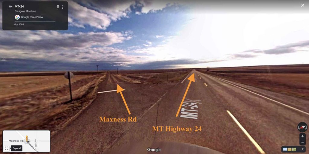
Screenshot, Google Maps
Due to the Refuge’s remote location and incredible size, visitors should be prepared for varying road conditions.
MT Highway 24 is paved and well-maintained. Otherwise, throughout the Refuge, visitors can expect rough, washboard roads that require a high-clearance, four-wheel-drive vehicle. Many of them are impassible, especially when wet.
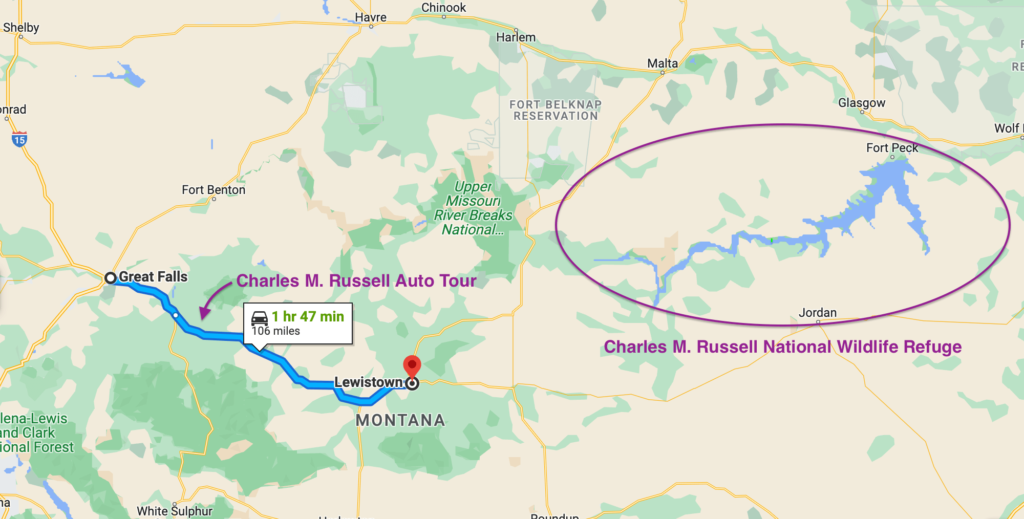
One popular scenic drive in this area is the Charles M. Russell National Wildlife Refuge auto tour, which follows a well-maintained road.
9. Charles M. Russell National Wildlife Refuge auto tour
The Charles M. Russell National Wildlife Refuge auto tour is one of the top activities among visitors of the Refuge. It’s not inside the boundaries of the Refuge but is named after the same iconic painter and offers a chance to see more prairie and beauty of north-central Montana.
The auto tour is a 100-mile stretch of Highway 87 between Great Falls and Lewistown. It takes about 2 hours to drive. The route passes through the Judith Basin, the inspiration for many of Charles M. Russell’s paintings, and along the way, you’ll see a stunning landscape of prairie, wooded ravines, and bluffs.
Fill up on plenty of drinking water, hop in your car, and enjoy!
Do you like scenic drives? Find out what makes Paradise Valley one of the best scenic drives in Montana
Can RVs and cars with trailers drive through the Charles M. Russell National Wildlife Refuge?
RVs and cars with trailers can drive through the Charles M. Russell National Wildlife Refuge. However, many of the roads are unpaved and have washboards, sharp turns, steep climbs, and descents. Many of them aren’t suitable for RVs and trailers, especially in bad weather.
If you have an RV or trailer, you’ll find easier driving on the paved roads and well-developed areas of the Refuge. For example, the Fort Peck Marina and RV Park and the Rock Creek Marina are well-equipped and offer full-service RV pitches.
Are pets allowed in the Charles M. Russell National Wildlife Refuge?
Dogs and cats are allowed in the Charles M. Russell National Wildlife Refuge. However, pets must be leashed in public spaces and owners must pick up after them.
Lodging in the Charles M. Russell National Wildlife Refuge
Here are some of the best accommodation options within the Charles M. Russell National Wildlife Refuge:
- Lakeridge Motel and Gas Station. Quaint, acceptable motel located on the north shore of the reservoir, just above the dam, about a 5-minute drive from Fort Peck. Features cabins with full kitchens and living rooms, or motel rooms with hot showers, heating, and air conditioning. All with a knowledgeable and friendly staff.
- Fort Peck Hotel. A beautiful, historic hotel right in Fort Peck just down the road from the Interpretive Center. It’s on the national register of historic places and offers rustic, quaint rooms, plus a restaurant.
- Rock Creek Marina. A marina with cabins for rent. The cabins have double beds, heating, air conditioning, microwave ovens, refrigerators, tables, chairs, and a walk-out deck. There is also a shop and a restaurant with reputable food on-site.
Most of the accommodation options throughout the Charles M. Russell National Wildlife Refuge are campgrounds.
You can also find hotels and other accommodation options in Glasgow, a 20-minute drive (18 mi, 29 km) north of Fort Peck.
Can you hunt the Charles M. Russell National Wildlife Refuge?
Hunting certain animals on the Charles M. Russell National Wildlife Refuge is permitted. However, a variety of wildlife is protected from hunting, such as bobcats, moose, bears, snakes, and prairie dogs.
Hunting on the Charles M. Russell Refuge is subject to Federal and State regulations. Refuge-specific hunting regulations can extend beyond Federal and State regulations, such as on big game hunting quotas.
Why are hunting regulations passed? Find out here
Can you fly drones in the Charles M. Russell National Wildlife Refuge?
Flying unmanned aircraft (drones) on or over Refuge lands is forbidden.
Why did they name this Montana refuge after Charles M. Russell?
The federal government renamed this Montana wildlife refuge after Charles M. Russell in 1963 because of the lasting impact his storytelling has had on the people and culture of this region of Montana.
In 1880, Charles M. Russell moved to Judith Basin near the present-day Wildlife Refuge in Montana. He painted iconic scenes, many of which are set in the Judith Basin, that capture the local culture in a signature style that is quickly recognizable today.
On a trip to Montana, you’ll likely see one of his paintings in an art boutique, hotel, or in someone’s home at some point on your journey.


