When did Montana become a state?
After 25 years as a territory, Montana became the 41st state of the United States on November 8, 1889, by presidential proclamation from President Benjamin Harrison.
Montana history timeline
Below we provide a visual timeline of when and how Montana became a state:
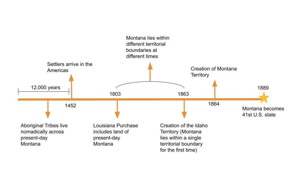
How did Montana become a state? (A condensed history of Montana)
For centuries preceding its official statehood in 1864, the land of present-day Montana lay within various territorial boundaries and unorganized swaths of land, depending on the time period you reference. These territories included the Indian Territory at the turn of the century and the Idaho Territory in 1863.
Following the mining boom in southwest Montana in the early 1860s, President Abraham Lincoln carved the Montana Territory from the Idaho Territory in 1864. Twenty-five years later, in 1889, due to its rising population and economic growth, President Harrison proclaimed the Montana Territory the 41st state of the United States.
Read on for the condensed story behind how Montana became a state. We start from the early days of the nomadic aboriginal tribes that followed the bison herds across present-day Montana for 12,000 years before the arrival of European colonists, and we end with President Harrison’s 1889 proclamation of Montana statehood.
This quick 5-minute read covers it all.
Montana, a land of nomadic aboriginals (Before the Europeans arrived)
Before European settlers arrived on the shores of America, the land of present-day Montana had been inhabited by humans for 12,000 years. The oldest human burial site in North America was discovered near present-day Wilsal, Montana.
Most of the indigenous tribes of this region were nomadic, following bison herds and other game as they lived in seasonal cycles.
Of the original tribes that still live in Montana today is the Crow, the first of the modern tribe to settle here, who arrived from Alberta, Canada in 1700. Today, their reservation is the largest of 7 reservations in Montana.
The 11 other native tribes that first lived in Montana include the Assiniboine, Blackfeet, Gros Ventre, and Kootenai.
European settlers arrive in the Americas
By 1452, Spanish settlers had arrived in the Americas, followed by the French, British, Dutch, and Russians, all of whom proceeded to colonize North and South America over the following centuries.
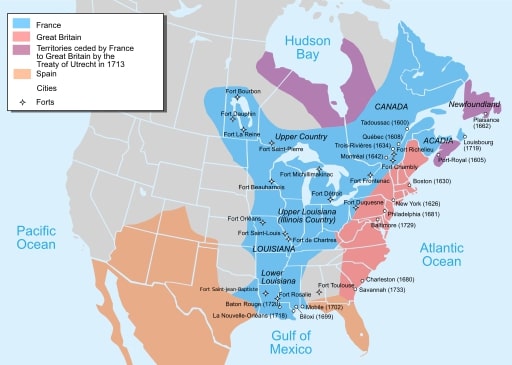
By the 1700s, the British had established the 13 original colonies, and France owned a swath of land stretching from the Gulf of Mexico to the Great Lakes and into the northwestern reaches of Canada. Spanish land stretched from the present-day southwestern U.S., on into Mexico, and beyond.
In 1803, in what was called the Louisiana Purchase, the United States acquired from France an enormous 828,000 square-mile swath of land that stretched from Louisiana to eastern Montana, west of the Mississippi. This opened the door for the United States to uncharted western regions of North America, triggering the next phase of westward exploration.
Westward exploration (Lewis & Clark)
With a penchant for scientific discovery and exploration and an interest in securing trade interests on the Pacific Coast, then-President Thomas Jefferson enlisted Captain Merriwether Lewis and William Clark to explore the newly acquired western regions of the Louisiana Purchase and establish a route to the Pacific Coast to secure trade interests.
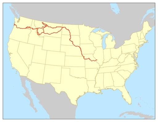
Also known as the Corps of Discovery Expedition, Lewis and Clark traveled up the Missouri to its headwaters, located in present-day Montana. After obtaining horses from the local Shoshone tribe, they continued west over the Continental Divide and the Rocky Mountains to the Columbia River, which carried them to the Pacific Coast.
Fur traders and settlers followed their trail west into Montana and the surrounding areas. Jesuit Missionaries also arrived, who taught the local native populations about agriculture, medicine, and religion.
St Mary’s Mission was constructed near present-day Stevensville around this time, on September 24, 1841, becoming the first European settlement in Montana. Numerous military forts and trading posts also followed, including Fort Benton, Fort Ellis, and Fort Shaw.
As the region became more settled, new territorial boundaries around present-day Montana emerged and shifted over the following decades.
Territorial boundaries emerge and shift
Throughout the early 1800s, the land of present-day Montana lay within different territories at different times, whose administrative centers lay hundreds, even thousands of miles away.
The territories that covered Montana during this time included:
- Indian Territory until 1805
- Louisiana Territory until 1812
- Missouri Territory until 1821
- General Great Plains Indian Country until 1854
- Nebraska Territory until 1861
By 1861, two territories covered Montana: the Dakota and Washington Territories.
Hints of Montana’s future
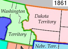
In 1861, two-thirds of eastern Montana lay within the Dakota Territory, while the northwestern portion of the state lay within the Washington Territory, a territory that had been carved from the eastern region of the previously established Oregon Territory.
In 1863, prospectors struck gold in Bannack (present-day southwest Montana), and miners began flocking to the region by the thousands. It wasn’t long before the local miners started pressing Congress for the establishment of their own territory in this area.
Creation of the Idaho Territory
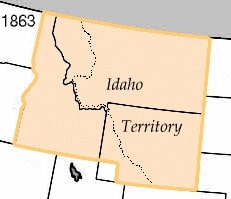
In 1863, congress responded by creating the Idaho Territory from the eastern segment of Washington Territory, western Dakota Territory, and northwestern Nebraska Territory. The newly established Idaho Territory covered all of Idaho and Montana and most of Wyoming.
The lands of present-day Montana were within a single territorial boundary for the first time.
However, the Idaho Territory turned out to be a geographical impossibility, and shortly after its creation, miners east of the Continental Divide started campaigning for a separate territory to be cut from the Idaho Territory.
Idaho Territory turns out to be a geographical impossibility
The Idaho Territory was split down the middle by the continental divide, and the population was steadily moving east to the mining camps on the upper Missouri.
Miners in Bannack and Virginia City felt that Lewiston, the administrative center of Idaho Territory, which lay hundreds of miles west over the jagged Rocky Mountains, couldn’t properly govern them, and began advocating for a new territory to be cut from the existing Idaho Territory.
In September 1863, the Idaho Territory’s newly appointed chief justice, Judge Sidney Edgerton, arrived in Bannack on his way to Lewiston. A former Ohio Congressman traveling from Ohio, he couldn’t proceed to Lewiston due to winter conditions in the Rockies.
Upon realizing the Idaho governor had assigned him to a distant judicial district east of the divide, he took up the settlers’ campaign. He also happened to be friends with then-President Abraham Lincoln, and with financial backing, he headed for Washington D.C. with vigilante leader Wilbur Fisk Sanders to push their case.
Montana Territory is carved from Idaho Territory
During this same time, the Idaho Legislature had obligingly started petitioning Congress for the creation of the new territory, and upon arriving in D.C., Edgerton discovered that Lincoln was open to the idea of a new territory in the Rockies.
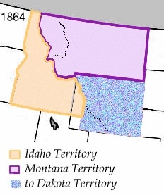
Despite a number of delays and a brief debate about the name ‘Montana’, the bill creating the Montana Territory swiftly passed through Congress, and on May 26, 1864, the new Montana Territory emerged with its jagged western border.
Interesting fact: After drawing the borders of Montana, Idaho, and Wyoming, Congress overlooked an 11mi2 (28 km2) piece of land between Idaho and Montana around present-day West Yellowstone. This land belonged to the Dakota Territory, 360 miles (580 km), and remained an ungoverned, uninhabited exclave for nine years. Today, it’s known as Lost Dakota.
Montana becomes a state
25 years later, on November 8, 1889, due to its large population and growing economy, President Benjamin Harrison proclaimed Montana the 41st state of the United States.
The borders of Montana haven’t changed since then.

